Mostrando entradas con la etiqueta Geography. Mostrar todas las entradas
Mostrando entradas con la etiqueta Geography. Mostrar todas las entradas
domingo, 6 de enero de 2013
domingo, 11 de noviembre de 2012
Lakes
Lakes of greece
Dojran Lake is a lake with an area of 43.1 km² shared between the Republic of Macedonia (27.3 km²) and West Macedonia within Greek Macedonia, Greece (15.8 km²). To the west is the city of Nov Dojran , to the east the village of Mouries, to the north the mountain Belasica/Beles and to the south the Greek town of Doirani. The lake has a rounded shape, a maximum depth of 10 m and a north-to-south length of 8.9 km and is 7.1 km at its widest, making it the third largest lake partially in the Republic of Macedonia after Lake Ohrid and Lake Prespa
Lake Kerkini, in Greece, is an artificial reservoir that was created in 1932, and then redeveloped in 1980, on the site of what was previously an extremely extensive marshland.
Prespa lake is the name of two freshwater lakes in southeast Europe, shared by Albania, Greece, and the Republic of Macedonia.
Lake Copais, Kopais, or Kopaida used to be in the centre of Boeotia, Greece, west of Thebes until the late 19th century. The area where it was located, though now a plain, is still known as Kopaida. While it still existed, the towns of Aliartos , Orchomenus, and Chaeronea were on its shores. Rivers running into the lake included the Cephissus, the Termessus, and the Triton. The lake was (and is) surrounded by fertile land, but the lake increasingly encroached on the surrounding land because of inadequate drainage. In response to this, in 1867–1887 Scots and French engineers reclaimed the land for the British company Lake Copais Ltd., by building channels to drain water from the lake to the Cephissus and from there to Lake Iliki. In total about 200 km² were reclaimed. This land was returned to the Greek government in 1952.

lunes, 5 de noviembre de 2012
Montains on Greece

In Southeastern Europe lies Greece, birthplace of the first great European civilization, a country of islands and coasts, about 2,000 islands in the Ionian and Aegean Seas. Also inside is very mountainous and is due to tourism in a valuable time to be considered a big draw. Walking and know a huge paradise such as Greece is a unique opportunity for all adventurous tourist, the walking tours with visits to archaeological remains are likely inevitable as is also visiting the great mountainous landscape that the country possesses, even practice mountaineering is added to new experiences with emotions.Greece has in its territory with more than 300 mountains are high or low interest par excellence. The backbone of the mainland's main mountain axis throughout Greece consists of the Pindos Mountains, they still mountains of the Peloponnese and Crete.Mount Olympus, which means 'the light', is the tallest mountain in Greece and so also the second of the Balkans; reaches 2.917 meters and is popular in Greek mythology. Located between Thessaly and Macedonia and is a nature reserve since 1938 and also from 1981, natural heritage of the European Union. One of its highest peaks is Mitikas with 2.917 meters, is followed with the Pico Eskolico 2.912 meters.About 40 sets to mountain across the country Greek exceed 2,000 meters of morphological variety and spectacular views. The unique landscapes in the Greek mountains are among the most coveted by tourists, some of the major sights are within natural forests oldest in Europe. This exceptional richness present in Greece is a must as it provides the right conditions to enjoy nature, the many activities in mountain tourism and winter.
martes, 30 de octubre de 2012
Geography
GEOGRAPHY OF GREECE
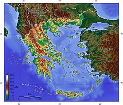
Greece is a country located in Southern Europe, on the southern end of the Balkan Peninsula. Greece is surrounded on the north by Bulgaria, the Republic of Macedonia and Albania; to the west by the Ionian Sea; to the south by the Mediterranean Sea and to the east by the Aegean Sea and Turkey. The country ranges approximately in latitude from 35°00′N to 42°00′N and in longitude from 19°00′E to 28°30′E. As a result, it has considerable climatic variation, as discussed below. The country consists of a large mainland; the Peloponnese, a peninsula connected to the southern tip of the mainland by the Isthmus of Corinth; and a large number of islands, including Crete, Rhodes, Corfu, the Dodecanese and the Cyclades. According to the CIA World Factbook, Greece has 13,676 kilometres (8,498 mi) of coastline [1]
80% of Greece is mountainous, and the country is one of the most mountainous countries of Europe. The Pindus, a chain of mountains lies across the center of the country in a northwest-to-southeast direction, with a maximum elevation of 2637 m. Extensions of the same mountain range stretch across the Peloponnese and underwater across the Aegean, forming many of the Aegean Islands including Crete, and joining with the Taurus Mountains of southern Turkey. Central and Western Greece contain high and steep peaks dissected by many canyons and other karstic landscapes, including the Meteora and the Vikos Gorges - the latter being one of the largest of the world and the third deepest after the Copper Canyon in Mexico and the Grand Canyon in the USA, plunging vertically for more than 1,100 metres. Mount Olympus is the highest point of Greece and the fourth highest in relative topographical prominence in Europe, rising to 2,919 m above sea level. The Rhodope Mountains form the border between Greece and Bulgaria; that area is covered with vast and thick forests. Plains also are found in eastern Thessaly, in central Macedonia and in Thrace. Western Greece contains lakes and wetlands.
Suscribirse a:
Entradas (Atom)